Bamiyan Before the Buddhas: What the Valley Looked Like at Its Peak
The story most people know about Bamiyan begins in March 2001, when the Taliban detonated the two largest standing Buddha statues in the world. That story, of loss and cultural annihilation, is real and worth telling. But there is an older story that runs in the opposite direction. It is the story of a valley that built those statues in the first place: a civilization at its height, a crossroads of empires, a place where merchants and monks and artists shaped something extraordinary out of sandstone cliffs at 2,500 metres above sea level. This is that story.
Where the Mountains Open
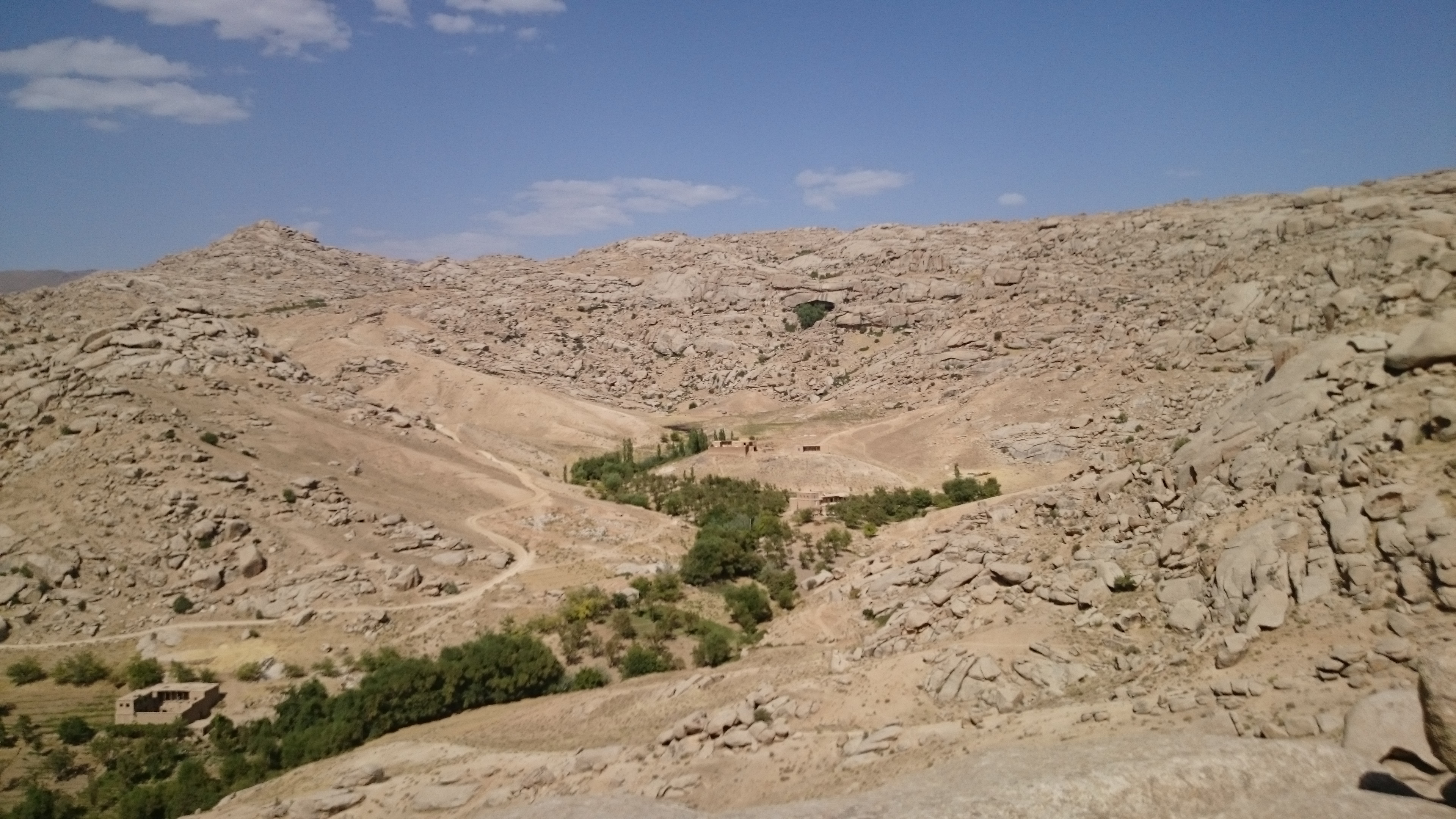
To understand Bamiyan, you have to understand the geography. The valley sits in the Hindu Kush range of central Afghanistan, enclosed on all sides by high peaks but opened by the Bamiyan River running along its floor. At its elevation, it is cold and snowbound much of the year, but in the warmer months it becomes a passage. The Hindu Kush effectively divides the Asian landmass, and Bamiyan sits at one of the few navigable corridors through it.
That position made Bamiyan indispensable on the Silk Road. UNESCO's Silk Roads Programme describes it as "a vital link in the trade routes that spanned from China to India via ancient Bactria." Caravans moving between the Mediterranean world, the Iranian plateau, India, and China had limited options for crossing the Hindu Kush. Bamiyan was one of them. That meant it saw everything: silk, spices, glassware, horses, copper, ideas, and people. It became, as UNESCO puts it, "a stop for trade caravans, a well-known artistic site and a major Buddhist center for centuries."
This was not incidental. The economics of a Silk Road stop shaped the culture of the place. Merchants needed lodging, food, and safety. A prosperous town needed administrators, artisans, and religious institutions. The cliff face that would eventually hold the Buddhas first held ordinary caves where people lived and stored goods. The valley had been inhabited since at least the 3rd century BCE. Long before the statues, there was a community.
The Kushan World
Buddhism did not arrive in Bamiyan independently. It came as part of a wider civilizational project driven by the Kushan Empire, one of the most consequential and underappreciated powers in world history.
The Kushans controlled a territory stretching from the Aral Sea to northern India between roughly the 1st and 3rd centuries CE. They made themselves, as the University of Washington's Silk Road Project describes, "the unavoidable middlemen between China, India and Rome," prospering on Silk Road revenues while developing a syncretic culture that fused Central Asian tribal traditions with Hellenistic artistic conventions and Indian Buddhist thought. This synthesis is sometimes called Greco-Buddhist art, or Gandhara art after the northwestern Indian region where it first flowered, and it is what gives the art of Bamiyan its distinctive character.
The Kushans were active patrons of Buddhism. Under their rule, Buddhism spread along the Silk Road into Central Asia and eventually into China, a transmission that shaped the entire religious and artistic history of East Asia. Monks established monastic centers at key points along the routes, and Bamiyan was one of the earliest and most significant of these. Evidence of Buddhist settlement there dates to Kushan times, and by the 5th century CE the valley was regularly mentioned in Chinese traveler accounts as a major center.
What made the Kushans unusual was their tolerance. They did not enforce a state religion. Their coins bore images of Greek, Iranian, Indian, and Buddhist figures side by side. Their artists absorbed Hellenistic techniques (the treatment of drapery, the modeling of the human face, the representation of the Buddha in human form for the first time anywhere) and combined them with Indian iconographic traditions. The result was an art that looked like nothing before it and influenced everything that came after.
When the Buddhas Were Carved
The two colossal Buddhas that would stand in Bamiyan for more than fourteen centuries were not carved during the Kushan period itself. Carbon dating of their structural materials places the smaller eastern statue (38 metres tall) at around 570 CE, and the larger western one (55 metres) at around 618 CE. This dates them to the period when the region was ruled by the Hephthalites, the confederation sometimes called the "White Huns," who had displaced Kushan authority in the 5th century but continued to patronize Buddhism and Buddhist art.
Who commissioned the statues specifically is not known. The archaeological record does not preserve a royal inscription or a dedicatory text that names a patron. What we do know is the tradition they stood within. The statues represent the Gandhara artistic school at scale: the treatment of their faces and robes shows influences from Gupta India and Sassanid Iran alongside the Hellenistic inheritance of the Kushan era. They were not local curiosities. They were the culmination of centuries of artistic cross-pollination along the Silk Road.
The scale was deliberate. The western statue, at 55 metres, was among the tallest standing Buddhas in the world. It would have been visible from a significant distance across the valley floor. For merchants arriving through mountain passes after days of hard travel, and for the monks who lived in the honeycomb of caves carved into the surrounding cliff, the statues were visible statements of what Bamiyan was: a place of consequence, a center of the Buddhist world.
The Chinese pilgrim Xuanzang, who visited Bamiyan in 630 CE, left one of the most vivid written accounts of the valley at its height. He described a kingdom with more than ten monasteries and a thousand monks, and noted that the larger Buddha's "golden hues sparkle on every side, and its precious ornaments dazzle the eyes by their brightness." The statues were not bare stone when Xuanzang saw them. They were gilded and painted, embedded in elaborate fresco compositions that covered the niches around them. The grain fields of the valley floor spread below, and sheep and horses grazed on the surrounding slopes.
A Civilization in the Cliffs
The Buddhas were the most visible element of something much larger. The cliffs around the valley contain hundreds of caves, many of them carved and shaped by human hands, forming what UNESCO describes as "a huge monastic ensemble dating from the 3rd to 5th century AD." Monks lived as hermits in small chambers cut into the cliff face. Larger caves served as assembly halls and shrines. The network of carved spaces stretched along the sandstone for kilometres.
Inside these caves, the walls were painted. Research published in the Journal of Analytical Atomic Spectrometry in 2008, by a team from the National Research Institute for Cultural Properties (Tokyo), the French Museums-CNRS, and the Getty Conservation Institute, produced a finding that surprised the art history community: twelve of the caves contained murals painted using oil-based pigments, most likely walnut and poppy-seed oils. These murals date to around the mid-7th century CE. The finding means Bamiyan's Buddhist painters were using oil-based techniques roughly six centuries before oil painting is conventionally said to have emerged in Europe. This was not a primitive outpost. It was a sophisticated artistic environment producing technically advanced work.
The frescoes show a similar eclecticism to the statues themselves. Scholars have identified stylistic influences from Gupta India, Sassanid Iran, and the Hellenistic artistic tradition. Seated Buddhas, celestial figures, geometric patterns, and floral motifs appear across the cave walls, painted in red, blue, and ochre. The Kakrak Valley, a side valley near Bamiyan, held a separate 6.5-metre standing Buddha and additional frescoes. The region was, in effect, an extended artistic complex.
On a hill overlooking the valley floor stands another site of an entirely different kind: Shahr-e-Gholghola. Before the Mongol invasion of 1221 transformed it into what later generations called the "City of Screams," it was a fortified royal citadel, the administrative heart of the Bamiyan kingdom during the Ghurid period (1155 to 1212 CE). Its ruins now offer a vantage point across the whole valley: the cliff face, the empty niches where the Buddhas stood, the river below, and the mountains beyond. The city controlled passage through the valley and extracted the revenues that made Bamiyan prosperous.
Empire Shifts, Valley Endures
Bamiyan passed through many hands. After the Kushans came the Sassanids, who were Zoroastrian by faith but generally tolerant of Buddhism in their territories, and under whose nominal authority additional Buddhist construction took place at Bamiyan. The Hephthalites followed. Then Turkic confederations held power in the region. Each transition shifted the political landscape without erasing what the valley had built.
The disruption came not from political transition but from religious transformation. The arrival of Islam in the region during the 7th and 8th centuries began a slow process of cultural change. The monasteries declined. The monks dispersed or converted. The artistic tradition that had produced the cave frescoes lost its patronage. By the time the Ghaznavid Empire consolidated control in the 10th century, Buddhism in the region was in significant retreat. The valley remained inhabited and strategically important, but the monastic civilization that had made it distinctive was fading.
The blow that ended Bamiyan's medieval urban life came in 1221. Genghis Khan laid siege to the city, and following the death of a beloved grandson during the campaign, issued an order of total destruction. According to Mongol-era chronicles, every person, animal, and living creature in the city was to be killed, and no booty was to be taken. The city that emerged from that siege earned a new name, Mao-Kurgan, the cursed city. It did not fully recover for generations.
What the Hazara Inheritance Means
The Hazara people have lived in Bamiyan continuously for as long as records document the valley's population. Their relationship to the pre-Islamic history of the place is complex and contested. They did not build the Buddhas; by the scholarly consensus, the Hazara ethnic identity as we now recognize it crystallized after the Mongol period, probably from a mix of earlier local populations and groups who came into the region over successive centuries. The genetic and linguistic picture is mixed, reflecting layers of Turkic, Mongolic, and Iranic influence.
But the claim to Bamiyan does not depend on an unbroken biological line to the craftsmen who carved the niches. It rests on something simpler and more durable: continuous presence. The Hazara have lived in that valley, farmed its fields, and looked at those cliffs for the entire period of recorded Hazara history. They developed their own relationship to the statues, not a Buddhist one but a cultural one. In Hazara oral tradition, the two Buddhas are figures named Salsal and Shahmama, a couple separated by fate. The story is entirely their own, adapted to a landscape that was already ancient when their community took shape.
When the statues were destroyed in 2001, the international response focused on cultural heritage in the abstract. What that framing missed is that the valley was not a museum. It was someone's home, and had been for a very long time. The pre-Islamic civilization of Bamiyan, the monks in their carved cells, the painters mixing poppy oil into their pigments, the merchants who stopped in the valley on their way between empires, left traces in the rock that outlasted their own world by more than a thousand years. That they outlasted it at all says something about what was built there. That they were deliberately destroyed says something about what was feared.
What remains in the cliff face are the empty niches: vast carved recesses, still perfectly shaped, still visible for kilometres across the valley floor. The shape of what stood there is preserved in the negative space. So is a good deal else, if you know where to look.
Related reading: The Buddhas of Bamiyan: What Was Lost and What Remains - the destruction, the Hazara connection, and what the empty niches mean today.
Sources consulted:
- UNESCO Silk Roads Programme - Bamiyan: https://en.unesco.org/silkroad/content/bamiyan
- UNESCO World Heritage Centre - Cultural Landscape and Archaeological Remains of the Bamiyan Valley: https://whc.unesco.org/en/list/208/
- Britannica - Bamiyan: https://www.britannica.com/place/Bamiyan
- Smarthistory - Bamiyan Buddhas: https://smarthistory.org/bamiyan-buddhas/
- Khan Academy - Bamiyan Buddhas: https://www.khanacademy.org/humanities/ap-art-history/west-and-central-asia-apahh/central-asia/a/bamiyan-buddhas
- National Geographic - The Daring Journey to Bamiyan: https://www.nationalgeographic.com/history/article/the-daring-journey-to-reach-afghanistans-famous-buddhas
- University of Washington Silk Road Project - Kushan Empire: https://depts.washington.edu/silkroad/exhibit/kushans/essay.html
- ScienceDaily - Ancient Buddhist Paintings Made of Oil (2008): https://www.sciencedaily.com/releases/2008/04/080422083309.htm
- Archaeology Magazine - Top Discoveries of 2008 - Oldest Oil Paintings: https://archive.archaeology.org/0901/topten/oldest_oil_paintings.html
- Minority Rights Group International / Refworld - Hazara Heritage and the Bamiyan Buddhas (2016): https://www.refworld.org/reference/annualreport/mrgi/2016/en/111176
- Study Buddhism - History of Buddhism in Afghanistan: https://studybuddhism.com/en/advanced-studies/history-culture/buddhism-in-central-asia/history-of-buddhism-in-afghanistan
- Nembutsu.cc - The Journeys of Xuanzang, Part Five: Bamiyan Bound: https://nembutsu.cc/2025/01/03/the-journeys-of-xuanzang-part-five-bamiyan-bound/
ترجمه فارسی
بامیان پیش از بتها: درّه در اوج خود چگونه به نظر میرسید
داستانی که بیشتر مردم دربارۀ بامیان میشناسند، در مارچ ۲۰۰۱ آغاز میشود، وقتی طالبان دو بزرگترین بت ایستادۀ جهان را منفجر کردند. آن داستان، که داستان فقدان و نابودی فرهنگی است، واقعی است و ارزش گفتن دارد. اما داستانی کهنتر هست که در جهت مخالف میرود. این داستان درهای است که آن بتها را در آغاز ساخت: یک تمدن در اوج خود، چهارراهی از امپراتوریها، جایی که تاجران و راهبان و هنرمندان از صخرههای ماسهسنگ در ارتفاع ۲٬۵۰۰ متر بالاتر از سطح بحر، چیزی فوقالعاده ساختند. این آن داستان است.
جایی که کوهها گشوده میشوند
برای فهم بامیان، باید جغرافیا را بفهمید. این دره در رشتهکوه هندوکش در مرکز افغانستان قرار دارد، از هر سو با قلههای بلند بسته اما با دریای بامیان که در کف آن جاری است، گشوده. در ارتفاع خود، بیشتر سال سرد و پربرف است، اما در ماههای گرمتر به یک گذرگاه بدل میشود. هندوکش عملاً پیکر آسیا را تقسیم میکند، و بامیان در یکی از معدود کوریدورهای قابل عبور از آن قرار دارد.
آن موقعیت، بامیان را در راه ابریشم ناگزیر میساخت. Silk Roads Programme یونسکو آن را «حلقهای حیاتی در راههای تجاری که از چین تا هند از طریق باختر باستان گسترش مییافت» توصیف میکند. کاروانهایی که میان جهان مدیترانه، فلات ایران، هند و چین حرکت میکردند، گزینههای محدودی برای گذر از هندوکش داشتند. بامیان یکی از آنها بود. این یعنی همه چیز را میدید: ابریشم، ادویه، شیشهآلات، اسب، مس، اندیشهها و مردمان. به این بدل شد، چنانکه یونسکو میگوید، «یک ایستگاه برای کاروانهای تجاری، یک سایت هنری شناختهشده و یک مرکز بزرگ بودایی برای قرنها.»
این تصادفی نبود. اقتصاد یک ایستگاه راه ابریشم، فرهنگ این مکان را شکل میداد. تاجران به اسکان، خوراک و امنیت نیاز داشتند. یک شهر مرفه به مدیران، صنعتگران و نهادهای دینی نیاز داشت. صخرهای که سرانجام بتها را در خود نگه داشت، نخست غارهای معمولی را نگه میداشت که مردم در آن زندگی و کالا انبار میکردند. این دره از دستکم قرن سوم پیش از میلاد ساکن بوده است. مدتها پیش از بتها، یک جامعه بود.
جهان کوشانی
بودایی بهطور مستقل به بامیان نرسید. بهعنوان بخشی از یک پروژۀ تمدنی گستردهتر آمد که توسط امپراتوری کوشانی، یکی از پراثرترین و کمقدرشناختهترین قدرتهای تاریخ جهان، پیش رانده میشد.
کوشانیها در فاصلۀ تقریبی قرن یکم تا سوم میلادی بر سرزمینی از دریای آرال تا شمال هند تسلط داشتند. آنان، چنانکه Silk Road Project دانشگاه واشنگتن توصیف میکند، خود را «واسطههای اجتنابناپذیر میان چین، هند و رم» ساختند، در حالی که از درآمدهای راه ابریشم رونق میگرفتند و یک فرهنگ همنشینانه را میپروراندند که سنتهای قبیلهای آسیای میانه را با کنوانسیونهای هنری هلنیستی و اندیشۀ بودایی هندی درمیآمیخت. این همنشینی گاه هنر یونانی-بودایی، یا هنر گاندارا به نام منطقۀ شمالغربی هند که نخست در آن شکوفا شد، نامیده میشود، و این آن چیزی است که به هنر بامیان خصلت متمایز آن را میدهد.
کوشانیها حامیان فعال بودایی بودند. زیر حکومت آنان، بودایی در راه ابریشم به آسیای میانه و سرانجام به چین گسترش یافت، یک انتقال که کل تاریخ دینی و هنری شرق آسیا را شکل داد. راهبان مراکز رهبانی در نقاط کلیدی در امتداد راهها برپا کردند، و بامیان یکی از زودترین و مهمترین اینها بود. شواهد سکونت بودایی در آنجا به زمان کوشانیها برمیگردد، و تا قرن پنجم میلادی این دره بهطور پیوسته در روایتهای مسافران چینی بهعنوان یک مرکز بزرگ ذکر میشد.
آنچه کوشانیها را غیرمعمول میساخت، تسامحشان بود. آنان دین دولتی را اجرا نمیکردند. سکههای آنان تصاویر چهرههای یونانی، ایرانی، هندی و بودایی را در کنار هم داشتند. هنرمندانشان تکنیکهای هلنیستی را جذب کردند (پرداخت پارچه، مدلسازی چهرۀ انسانی، ارائۀ بودا در شکل انسانی برای نخستین بار در هر جایی) و آن را با سنتهای شمایلنگاری هندی ترکیب کردند. نتیجه هنری بود که شبیه به هیچ چیز پیش از خود نبود و بر هر چیز پس از خود تأثیر گذاشت.
بتها چه زمانی تراشیده شدند
دو بت غولپیکر که بیش از چهارده قرن در بامیان ایستاد، در خود دورۀ کوشانی تراشیده نشدند. تاریخگذاری کربنی مواد ساختاریشان، بت کوچکتر شرقی (به ارتفاع ۳۸ متر) را در حدود ۵۷۰ میلادی و بزرگتر غربی (۵۵ متر) را در حدود ۶۱۸ میلادی قرار میدهد. این آنها را به دورهای میرساند که منطقه توسط هفتالیان، کنفدراسیونی که گاه «هونهای سفید» نامیده میشود، اداره میشد، که در قرن پنجم اقتدار کوشانی را جابهجا کرده بودند اما به حمایت از بودایی و هنر بودایی ادامه میدادند.
این که چه کسی بهطور خاص بتها را سفارش داد، شناختهشده نیست. سابقۀ باستانشناسی یک کتیبۀ شاهی یا متن وقفی که نام حامی را ببرد، حفظ نکرده است. آنچه میدانیم، سنتی است که آنها در آن ایستاده بودند. این بتها مکتب هنری گاندارا را در مقیاس بزرگ نشان میدهند: پرداخت چهرهها و جامههایشان نفوذهایی از هند گوپتا و ایران ساسانی را در کنار میراث هلنیستی دورۀ کوشانی نشان میدهد. آنها کنجکاوی محلی نبودند. آنها اوج قرنها گردهافشانی متقابل هنری در امتداد راه ابریشم بودند.
مقیاس عامدانه بود. بت غربی، با ارتفاع ۵۵ متر، در میان بلندترین بتهای ایستادۀ جهان بود. از فاصلۀ چشمگیری در سراسر کف دره دیده میشد. برای تاجرانی که پس از روزها سفر سخت از طریق گذرگاههای کوهستانی میرسیدند، و برای راهبانی که در کندوی غارهای تراشیدهشده در صخرۀ پیرامون زندگی میکردند، بتها بیانیههای قابل دیدنی بودند از این که بامیان چه بود: مکانی پرپیامد، مرکزی از جهان بودایی.
زائر چینی Xuanzang، که در ۶۳۰ میلادی از بامیان دیدن کرد، یکی از زندهترین روایتهای نوشتاری دره را در اوج خود به جا گذاشت. او پادشاهیای را با بیش از ده صومعه و هزار راهب توصیف کرد، و اشاره کرد که «درخشش طلایی [بت بزرگتر] از هر سو میدرخشد، و زیورهای گرانبهای آن چشمان را با درخشندگیشان خیره میسازد.» وقتی Xuanzang آنها را دید، بتها سنگ برهنه نبودند. زراندود و نقاشیشده بودند، در ترکیبهای فرسکوی مفصل که محرابهای پیرامونشان را پوشانده بود جای گرفته بودند. زمینهای غلۀ کف دره در زیر گسترده میشد، و گوسفند و اسب در دامنههای پیرامون چرا میکردند.
یک تمدن در صخرهها
بتها قابل دیدنیترین عنصر چیزی بسیار بزرگتر بودند. صخرههای پیرامون دره صدها غار را در خود دارد، که بسیاری از آنها توسط دستان انسان تراشیده و شکل داده شدهاند، و آنچه را یونسکو «یک مجموعۀ رهبانی عظیم از قرن سوم تا پنجم میلادی» توصیف میکند، میسازند. راهبان بهعنوان زاهد در اتاقکهای کوچک بریدهشده در صخره زندگی میکردند. غارهای بزرگتر بهعنوان تالار اجتماع و معبد خدمت میکردند. شبکۀ فضاهای تراشیدهشده در امتداد ماسهسنگ کیلومترها گسترش مییافت.
در درون این غارها، دیوارها نقاشی شده بودند. پژوهش منتشرشده در Journal of Analytical Atomic Spectrometry در ۲۰۰۸، توسط یک تیم از National Research Institute for Cultural Properties (توکیو)، French Museums-CNRS، و Getty Conservation Institute، یافتهای را تولید کرد که جامعۀ تاریخ هنر را شگفتزده کرد: دوازده غار حاوی نقاشیهای دیواری بودند که با رنگدانههای پایه-روغنی، به احتمال زیاد روغن گردو و دانۀ خاشخاش، نقاشی شده بودند. این نقاشیهای دیواری به حدود میانۀ قرن هفتم میلادی برمیگردد. این یافته یعنی نقاشان بودایی بامیان از تکنیکهای پایه-روغنی استفاده میکردند که تقریباً شش قرن پیش از زمانی است که نقاشی روغنی بهطور معمول گفته میشود در اروپا پدید آمد. این یک پاسگاه ابتدایی نبود. یک محیط هنری پیچیده بود که کار از نظر تکنیکی پیشرفته تولید میکرد.
فرسکوها انتقادی مشابه با خود بتها را نشان میدهند. پژوهشگران تأثیرات سبکی را از هند گوپتا، ایران ساسانی، و سنت هنری هلنیستی شناسایی کردهاند. بوداهای نشسته، چهرههای آسمانی، نقشمایههای هندسی، و نقشمایههای گل در سراسر دیوارهای غار ظاهر میشوند، با رنگهای سرخ، آبی و اخرا نقاشیشده. درۀ کاکرک، یک درۀ جانبی نزدیک بامیان، یک بت ایستادۀ جداگانۀ ۶.۵ متری و فرسکوهای اضافی را در خود داشت. این منطقه، در عمل، یک مجموعۀ هنری گسترشیافته بود.
روی تپهای مشرف به کف دره، یک سایت دیگر از نوعی بهکلی متفاوت ایستاده است: شهر غلغله. پیش از اینکه حملۀ مغول در ۱۲۲۱ آن را به آنچه نسلهای بعد «شهر فریادها» نامیدند تبدیل کند، یک قلعۀ پادشاهی مستحکم بود، قلب اداری پادشاهی بامیان در دورۀ غوریان (۱۱۵۵ تا ۱۲۱۲ میلادی). خرابههای آن اکنون نقطۀ دیدی به سرتاسر دره ارائه میدهد: صخره، محرابهای خالی جایی که بتها ایستاده بودند، دریای زیر، و کوههای ورای آن. این شهر گذر از دره را کنترل میکرد و درآمدهایی را که بامیان را مرفه میساخت برمیداشت.
امپراتوریها جابهجا میشوند، دره دوام میآورد
بامیان از دستان بسیار گذشت. پس از کوشانیها، ساسانیان آمدند، که از نظر دینی زرتشتی بودند اما عموماً نسبت به بودایی در سرزمینهایشان تسامح داشتند، و زیر اقتدار اسمی آنان ساختوساز اضافی بودایی در بامیان صورت گرفت. هفتالیان پی آمدند. سپس کنفدراسیونهای ترکی قدرت را در منطقه در دست داشتند. هر گذار چشمانداز سیاسی را تغییر میداد بدون این که آنچه دره ساخته بود را پاک کند.
اختلال نه از گذار سیاسی، که از دگرگونی دینی آمد. ورود اسلام به منطقه در طول قرنهای هفتم و هشتم آغاز یک روند آرام تغییر فرهنگی بود. صومعهها افول کردند. راهبان پراکنده شدند یا گرویدند. سنت هنریای که فرسکوهای غار را تولید کرده بود، حمایت خود را از دست داد. تا زمانی که امپراتوری غزنوی در قرن دهم کنترل را تحکیم کرد، بودایی در منطقه در عقبنشینی چشمگیر بود. این دره ساکن و از نظر راهبردی مهم باقی ماند، اما تمدن رهبانیای که آن را متمایز میساخت، در حال محو شدن بود.
ضربهای که زندگی شهری قرون وسطایی بامیان را پایان داد، در ۱۲۲۱ آمد. چنگیز خان شهر را محاصره کرد، و پس از مرگ یک نواسۀ محبوب در طول کارزار، فرمان نابودی کامل صادر کرد. بر اساس سالنامههای دورۀ مغول، قرار بود هر فرد، هر حیوان، و هر موجود زنده در شهر کشته شود، و هیچ غنیمتی برداشته نشود. شهری که از آن محاصره بیرون آمد، نام تازهای به دست آورد، ماو-کورگان، شهر نفرینشده. نسلها بهطور کامل بهبود نیافت.
معنای میراث هزاره چیست
مردم هزاره به اندازهای که سوابق جمعیت دره را ثبت میکند، در بامیان بهطور پیوسته زندگی کردهاند. رابطۀ آنان با تاریخ پیش از اسلامی این مکان پیچیده و محل مناقشه است. آنان بتها را نساختند؛ بر اساس اجماع پژوهشی، هویت قومی هزاره چنانکه اکنون میشناسیم پس از دورۀ مغول متبلور شد، احتمالاً از آمیختهای از جمعیتهای محلی پیشین و گروههایی که در طول قرنهای متوالی به منطقه آمدند. تصویر ژنتیکی و زبانی آمیخته است، و لایههای نفوذ ترکی، مغولی و ایرانی را بازتاب میدهد.
اما ادعا به بامیان به یک خط زیستی پیوسته به صنعتگرانی که محرابها را تراشیدند، وابسته نیست. بر چیزی سادهتر و بادوامتر مینشیند: حضور پیوسته. هزارهها در آن دره زندگی کردهاند، زمینهای آن را زراعت کردهاند، و در سرتاسر دورۀ تاریخ ثبتشدۀ هزاره به آن صخرهها نگاه کردهاند. آنان رابطۀ خاص خود را با بتها پروراندند، نه یک رابطۀ بودایی بلکه یک رابطۀ فرهنگی. در سنت شفاهی هزاره، آن دو بت چهرههایی به نام صلصال و شهمامه هستند، زوجی که سرنوشت آنان را جدا کرده. این داستان کاملاً مال خودشان است، تطبیقیافته با چشماندازی که وقتی جامعهشان شکل گرفت از پیش باستانی بود.
وقتی بتها در ۲۰۰۱ تخریب شدند، پاسخ بینالمللی روی میراث فرهنگی بهطور انتزاعی متمرکز شد. آنچه آن چارچوببندی از دست داد این بود که دره یک موزه نبود. خانۀ کسی بود، و برای زمانی بسیار طولانی چنین بوده. تمدن پیش از اسلامی بامیان، راهبان در سلولهای تراشیدهشان، نقاشانی که روغن خاشخاش را در رنگدانههایشان میآمیختند، تاجرانی که در راه میان امپراتوریها در دره میایستادند، رد در صخره به جا گذاشتند که بیش از هزار سال از جهان خودشان بادوامتر بود. این که آنان اصلاً بادوام ماندند، چیزی دربارۀ آنچه در آنجا ساخته شد میگوید. این که آنان عامدانه ویران شدند، چیزی دربارۀ آنچه از آن میترسیدند میگوید.
آنچه در صخره میماند، محرابهای خالی است: فرورفتگیهای تراشیدۀ پهناور، هنوز کاملاً شکلگرفته، هنوز برای کیلومترها در سراسر کف دره دیده میشوند. شکل آنچه در آنجا ایستاده بود، در فضای منفی حفظ شده است. و خیلی چیزهای دیگر نیز، اگر بدانید کجا را نگاه کنید.